About Ramshehar
Solan District came into existence at the time of the reorganization of the districts of the State on Ist September, 1972. The District was carved out of Solan and Arki tehsils of the then Mahasu district and tehsils of Kandaghat and Nalagarh of the then Shimla District. Administratively, the district is divided into four Sub-division viz. Solan comprising of Solan and Kasauli tehsils, Nalagarh covers the jurisdiction of Arki and Kandaghat Sub-divisions covers their respective tehsils. The total geographical area of the district according to the Surveyor General of India is 1,936 sq. km. which constitutes 3.49 percent of the total area of the State and ranks 9th amongst the district. Ramshehar is sub tehsil (small administrative area) in Nalagarh tehsil with in Solan district.
Physical Features
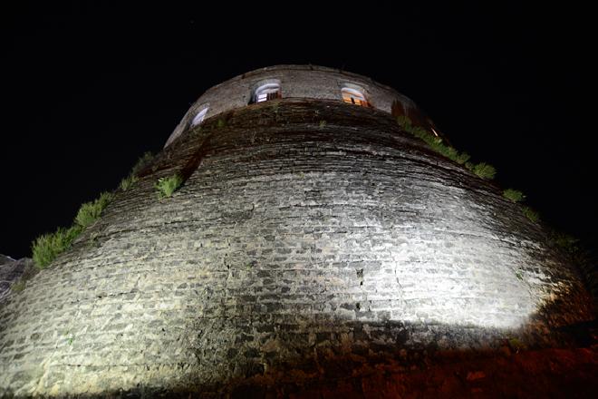
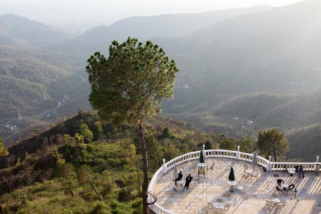
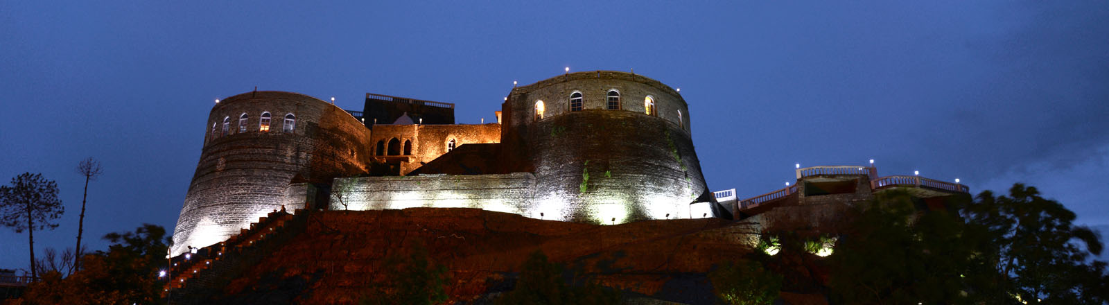
The mountains of lower elevation are found in western-southern parts of the district comprising of Nalagarh and Arki tehsils while higher ranges start from central region and extend upto north-eastern corner of the District comprising Solan tehsil and parts of Arki tehsil, Kasauli tehsil and Kandaghat tehsil which are located in north-eastern direction of the district and are having the highest ranges of the District. The elevation of the Ramshehar ranges from 600 to 15,00 metres above sea level. Ramshehar fort lies at the height of 3900 ft above sea level on a hill top having 360 degree view.
Climate
Autumn/Winter/Spring: October to April. Max. 31oC, Min. 4oC
Summer: May & June Max. 35oC, Min 20oC
Beautiful Place, awesome location, good scenery , delicious food , cordial staff nice hospitality.
Really Beautiful place to visit a lot of efforts done to restore the cultural heritage of our country
Wonderful . Not Enough Words To Convey Our Feelings. Fantastic Views, Exotic Infrastructure , Presentation And Luxurious Look.
Lonely Place. Will Definitely Come Back To Stay. Presently At Nalagarh.
Nice place for stay with good food and excellent hospitality.
Can't Wait For The Fort Portion To Open. I will surely visit the place . A grand heritage place it is going to be
A Beautiful Place & Would Like To Publish A Cover Story In Our Esteemed Newspaper. (19-01-2014)
Very Interesting Place , Very Nice Hospitality, good food and locations
The Stay Was Amazing & Specially The Quality Of Food And The Natural Beauty Of The Fort.
Wonderful Place , Good Food, Beautiful Scenery,Hope To Come Soon
An Aweosome Place at A Aweosome Location . Will Be One Of The Best Tourist Destination .Best In All Aspects.
Came for a short visit , the fort has been restored in the most natural manner with taste, grandeur and feel. The efforts are landable .This is bound to become a loved and preferred tourist attraction in times to comes, I am sure. The staff is very hospitable and caring. We had a wonderful time and very tasty lunch. My special thanks to Mr. Paramjeet Singh and other team members for taking good care of us. All the best (21 Aug 2016)
Nice & Cool Place. Well Maintained & Good Staff, beautiful location.
Very Nice Ambience. Well Maintained. Thanks For The Nice Experience.
Excellent Unique Experience. Yummy food, cordial staff. Loved spending every minute here
Amazing, Loved Every Minute Of It. Thanks for the nice experience
Nice location , tasty food, excellent service . Good Experience & Will Come Again.
VERY GOOD EFFORT TO PRESERVE THE FORT. NATURE IS AT THE BEST.IT IS VERY GOOD AND FANTASTIC VISIT BY SHYAMLALJI. THANK YOU.
Amazing Property & Great Staff. Amazing Food As Well. Overall Great Experience And A Great Place For Family Holiday
During Our Two Night Stay, We Had A Very Good Time In Every Aspect. The Room Was Equipped & All The Modern Facilities. The Fort Was Impressive. It Was Enjoyable To Climb Up To The Heights Of Fort And Got Opportunity To Know About Ancient Monuments Which Give Us Knowledge About The Gone By Years. The Efforts Made By The Management In Walking The Fort And Surroundings Lively Are Worth Praising. Restaurant- Very Good & Tasty Food & Excellent Presentation And Very Good Services Given By The Staff As The Whole. We Wish Excellent Future For This Place Regarding Prosperity & Business .
The Ramshehar Fort Regality At Its Best & Restoration Of History Like Never Before. Fine Hospitality, History, Tradition & Modernity All Finally Blended Together See History Come Alive At Fort Ramshehar Resort. Hats Off To Bansal Sir.
A Very Good Place . Nice Property .well maintained at such a remote location. Thanks.
Very Nice Place For Visit .A door to nature with all the modern and excellent facilities
Amazing Property. Beautiful scenery, tasty food , good service and hospitality
Nice Place, good and well maintained property with cordial staff , and nice hospitality
Nice Place, with awesome view , and hospitality. Beautiful mix of modern and traditional amenities. Want To Come Again
It Was Very Good To Visit Here. It Is Very Nice Hilly Place.
Awesome location, with a lot of natural surroundings and scenic views. Nice Place To View.
Beautiful Place with good staff , excellent location and awesome hospitality
Excellent .Peaceful . , Nice location, beautiful scenery .Calm Environment .
Wonderful Place & Food Quality Is Also Good, nice location , one of the best locations I must mention
Excellent Job Done to restore the heritage property of our country, which might have extinguished .
Excellent Property .Good Food And Excellent Service Done By Virender.
Good food , nice location, cordial staff .Wonderful Property .Nicely Maintained
The Visit Was Great. We Loved It And Will Come Again. Excellent Property .Good Food And Excellent Service Done By Virender.
Its a Great place to visit .Especially the staff was very nice and guided us well and showed the complete property and explained entire history .
Amazing Experience, delicious food , Great Service & Hospitality.
Good Wonderful,Excellent Work Has Done .All Of Us Every Enjoy This Place .Thanks
Amazing, Is The Lifetime Experience .Really Nice place for stay with good food and excellent hospitality.
Very Nice Place, awesome Climate, nice view , good location and scenery
A Very Good Heritage Property, Good Service, a lot of efforts done to save the rich heritage of our country.
A Good Place To Hangover, with good view , good place to spend time in peace and relax
Visited with family for the 1st time... We all just loved it... Nearby to Chandigarh, a good weekend spot... It's was my first time I stayed in a fort property and the experience was awesome... The view from Fort is breathtaking. Staff are good and polite.. Service, ambience are excellent.. Overall it was a very good experience.
A Very Nice Day Spent .It Was A Wonderful Day Wonderful heritage place..one should visit..osm view services are great..food quality was excellent..staff dealing was great..had wonderful tym there
Amazing, Is The Lifetime Experience .Really Nice we loved it here it was a grate and love to come again
Amazing Experience. Great Service & Hospitality. it is very good fantastic visit by shyamlal ji
Wonderful Property .Nicely Maintain .good staff very peaceful place keep it up
Very Nice Place For Visit, resort staff is very good and resort is also very fantastic and food was very good as well
Amazing Property , good food , nice location, and full of adventure
Wonderful heritage place..one should visit..osm view services are great..food quality was excellent..staff dealing was great..had wonderful tym there..it was a memorable visit..art gallery collection is great
A Good Attemp To Preserve Culture. it was very good to visit here it is very nice hill place . love to come again
very good experience wonderful place good food Beautiful scenery , hope so come come to again ,& Ultimate To Stay . thank u
It Is Very Good. good hospitality . love to come again From The Core Of My Heart Thanks U Very Much.
Excellent Place. I Would Like To Visit Again .I Family & Frends For Weekend Holiday As In Very Much Approached From Ludhiana. My Family Really Enjoyed . The Food Quality Was Excellent.
Amazing Property. Wanna very good place very well maintained & staff is also co- operative & Visit Again.
Awesome Experience, Sure Will Visit Again.Amazing Property. Wanna very good place very well maintained love to come again
Wonderful Place For Visit. Really A Nice Place very good experience wonderful place good food Beautiful scenery
Very Interesting Place ,Very Nice Hospitality Unique & Different, Good Maintain,Co-Operative Staff And Helpful Guide
Nice Location With Beautiful Views & Humble Staff love to come again
An awesome place for offsite or outbound trainings as well as corporate retreat. Few Pointers 1. Staff is very polite 2. View from literally every room is mind blowing 3. Food is above average if not exceptional 4. Do try local food items like "ambua ki sabzi" (dish made from mangoes) 5. Take appropriate clothing and Tannning material as sun gets a bit harsh sometimes Look for mini treks and the secret tunnel under the fort... A small yet fun adventure
Very Interesting Place ,Very Nice Hospitality. good staff good experience & will come to again
The Visit Was Great. We Loved It And Will Come Again
Nice Place Wants To Come Again Good Service & Wonderful Stay Food Was Good Over All Experience Was Good.
A Very Calm And Cool Place For Stay. A Gignastic Job. Weldone Very Nice Food,Stay And Staff, Keep It Up.
Very Nice Place. Beautiful Place. Climate Is So Better. Enjoyed A Lot. Thanks.
Came for a short visit , the fort has been restored in the most natural manner with taste, grandeur and feel. The efforts are landable .This is bound to become a loved and preferred tourist attraction in times to comes, I am sure. The staff is very hospitable and caring. We had a wonderful time and very tasty lunch. My special thanks to Mr. Paramjeet Singh and other team members for taking good care of us. All the best
Well Preserved Heritage Awesome Location.
Good Service & Wonderful Stay Food Was Good Over All Experience Was Good. love to come again
Good Stay Good Staff Very Nice Place. Beautiful Place. Climate Is So Better. Enjoyed A Lot. Thanks
Best Place To Visit Among The Places To Have Seen So Far.
Excellent Room Service Very Co-Operative Staff Quality Of Food Worth Like To Visit Again &Again& Again
Excellent Room Service Very Co-Operative Staff Quality Of Food Worth Like To Visit Again &Again& Again.
Awesome Experience & Food & Ambience Like To Come Again.
Very Nice Building And Excellent Hospitality.
Very Well Maintained & Staff Is Also Co-Operative.
Lodging And Food Is Good Very Co-Operative Staff.
Very Good Facilities And Well Maintained.
Good Property Delicious Food And Very Good Co-Operative Staff.
Nice Place With Historical Importance, Good Hospitality.
Nice Place With Historical Importance, Good Hospitality.
Very Nice Food,Stay And Staff, Keep It Up.
Had Two Wonderful Days On This Out With Our 30 Managers .Nice Stay Nice Hospitality Ideal For Such Activities Like Training Etc. Will Like To Come Again With Family.
Good Service And Location And People Are Good love to come again .
Good Service And Location And People Are Good.
Very Good Service Staff Is Also Humble , Caring and love to come again
Very Good Hospitality And Staff Is Also Very Good .
Great Experience, Far Batter Then The Last Time, Would Love To Visit Again.
Nice Place To Hang Out With Family.
Nice Ambience. Very Good Service And Very Good Food .
Excellent Ambience And Nice Hospitality. love to come again
Nice Ambience. Very Good Service And Very Good Food Had A Great Time! Thanks.
Nice Ambience. Very Good Service And Very Good Food Had A Great Time! Thanks.
Had A Great Time! love to come again Thanks.
Very Nice Ambience & Cordial Staff. Amazing Experience. Shall Come Back With Whole Family.
It Was Amazing. Staff Is Good And Helping, Tasty Food, Thank You.
It Was Amazing. Staff Is Good And Helping, Tasty Food, Thank You.
Short And Enjoyable Stay. Courtous Staff & Prompt Service.
Excellent Venue. Good Service By Mr. Shyam Lal.
It Is A Very Good Property With Very Nice Staff. Good Service.
It Is A Very Good Property With Very Nice Staff. Good Service. Nice Property.
It is one of the best property I must say , an awesome place for corporate events , weddings , family get together , as an event planner I must say one of the unique property and place with awesome staff and service .
It Is A Very Good Property With Very Nice Staff. Good Service. Comfortable & Enjoyed Lots.
Nice N Pleasant Stay. Definitely Will Visit Again.
Very Nice And Beautiful. Will Come Again. Staff Is Very Good. love to come again
Very Nice Place For Stay And Visit.
Very Nice And Beautiful. Will Come Again. Staff Is Very Good.
Nice To Stay Here, All Staff Is Cooperative, Food Was Nice, Specially Staff Cooperative.
Loved The Property. Food Is Awesome. Service Needs Improvement.
Great Resort, Beautiful Place, Good Maintenance, Nice Staff, Good Facilities.
Great Resort, Awesome View, Great Fort, Nice Staff.
Great Resort, Beautiful Place, Good Maintenance, Nice Staff, Good Facilities. Very Peaceful Place.
Pleasant Weather, Nice Property.
Nice Ambience. Very Good Service And Very Good Food Had A Great Time! Thanks.Good.
Very Very Good. Awesome Place. Good Attenedation And Service. Experience Was Very Good.
Nice To Visit Here As All Are Very Nice. And Location Is Also Too Good.
Nice Resort & Nice Location For Having Peace Time With Family & Friends.
Nice Peaceful Stay. We Will Remember. Thanks.
Very Good Experience. Love To Come Againand Stay Back With You.
Excellent Service, Class Exotic. Resort And Visited. Seven Star With Five Star Rating.
Very Very Good Experience. Love To Come Again Stay With You.
Good Attenedation And Service. Experience Was Very Good.
It Is Amazing & Mr. Shyam Has Made Our Stay Wonderful With His Experienced Style Of Handling Situation.
The Ramshehar Fort Resort Has Given A New Look To The Tourism In Shivalik Hills. Nice Place To Visit.
Excellent Hospitalityexperienced. Love My Stay. Would Like To Visit Again And Again. Comendable Job Done By Paramjit The Project Manager. Keep Up The Good Work.
Beautiful Location And Landscaping With Picturesque View. Good Staff.
Awesome Views, Nice Hospitality, Very Neat And Clean Rooms.
Very Nice View And Room Very Neat and Staff Is Very Very Good.
Good Place. The Staff Needs To Be More Courteous And Polite.
Very Good, nice food , delicious food , good service , overall a nice place to visit
It Is Very Nice Place To Visit. Service Is Too Good.
Good, Interesting Place. Food Quality Excellent. Encourage Room Service.
Shyamlal Is A Great Man. Very Pleasant Personality.
Superb Location, Awesome Food.Very Good Place. All Staff Members Are Very Good. We All Enjoy With Friends.
Excellent Place, Keep It Up.It Is A Very Good Property With Very Nice Staff. Good Service.
Had A Wonderful Stay. Love It. Great Service & Hospitality By Mr. Shyam Lal.
This Is Really A Wonderful Place And Experience Of Royality.
Beautiful, Incredible Scenery , nice hospitality and location .
Nice And Beautiful Place. Enjoy Food And Hill View. Good Family.
Very Good Place. All Staff Members Are Very Good. We All Enjoy With Friends.
Very Nice Place. All Staff Members Help Us To Success A Wonderful Picnic.
Great Service & Hospitality By Mr. Shyam Lal.
Place Is Fabulas And Adorable. Thanks For All.
Awesome Place, Nice View Around The Fort, We Have Enjoyed The Food. I Feel This Was A Nice Weeked As We Planned.
Nice Place With Awesome View And Nice Food With Good Service And Good Assistancefrom Staff. Thanks To Mr. Shyam Lal For Fort Visit And Their Assistance.
Very Good, A Beautiful Place.
A Big Thanks To Front Desk Staff Firstly, Very Pleasant Staff. Efficient Housekeeping And Restaurant Staff. To Maintan This Kind Of Heritage Property Is A Very Cumbersome Task. I Wish All The Very Best To Sh. Parveen Bansal Ji. To Keep The Staff Swiling & Efficient Credit Goes To Gm. I Wish All The Very Best @ Success To All Staff Members & Especially Mr. Vipin Gaur, A Very Friendly Person Indeed.
Nice Stay. Good Property, Food Is Very Nice, Staff Very Humble And Helpful.
Veri Confortable And Excellent Staff. Tip : Guide Need To Be More Information About The Fort, History, Architecture Etc.
Good, Good Is Also Yummy N Tasty, Service Required To Be Improve.
Awesome! It was A discovery. Beautiful Property. Very courteous staff. We had a great time. Will visit again very soon.
Awesome place to visit with friends and family, specially camping loving guys. We got the open place and wonderful weather for outdoor games.We loved the staff service, hospitality and their behavior. They made us so comfortable and helped us at every moment. Special mention of Mr. Vipin, Ms. Preeti, Mr. Amarjeet, Mr. Santosh and the cooking staff. Food was so delicious I cant express in words. We got the chance to play pool holi which was a great fun and Yes... the bonfire that added to our masti. Just loved this place...Guys u must visit this place...
Good atmosphere for a quiet hotel. Car Parking Area is so much, clean and comfortable. Beautiful rooms and beautiful decor throughout. Ate at the Met Bar and food was exceptional. Great value for money all round.
Superb Place. Staff Is Excellent. Virender Knows His Job well. Very Happy Will Come Soon.
GOOD HOSPITALITY. LOVE TO COME AGAIN. GOOD STAFF. FOOD WAS GOOD. THANKS.
GOOD PROPERTY, VERY GOOD FOOD. NEED TO IMPROVE THE SERVICE. MUST HAVE SPA. GOOD VIEW.
VERY GOOD PLACE. VERY WELL MAINTAINED & STAFF IS ALSO CO-OPERATIVE.
VERY GOOD, EXCELLENT STAFF. GOOD EXPERIENCE & WILL COME AGAIN.
BEAUTIFUL PLACE ,AWESOME LOCATION ,GOOD SCENERY , DELICIOUS FOOD , CORDIAL STAFF NICE HOSPITALITY.
IT IS VERY GOOD AND FANTASTIC VISIT BY SHYAMLALJI. THANK YOU.
VERY NICE PROPERTY. AWESOME EXPERIENCE & FOOD & AMBIENCE LIKE TO COME AGAIN.
NICE PROPERTY, GOOD STAFF, VERY PEACEFUL PLACE , KEEP IT UP.
VERY GOOD PROPERTY, EXCELLENT SERVICE. VERY GOOD STAFF.
GREAT PROPERTY, EXCELLENT LOOK AFTER, KEEP DOING THE GOOD WORK.
EXCELLENT EXPERIENCE. NICE PLACE FOR STAY WITH GOOD AND EXCELLENT AND EXCELLENT HOSPITALITY.
VERY GOOD EXPERIENCE.Wonderful Place , GOOD FOOD, BEAUTIFUL SCENERY , HOPE TO COME SOON.
RESORT STAFF IS VERY GOOD AND RESORT IS ALSO FANTASTIC. FOOD WAS VERY GOOD AS WELL.
IT WAS A WONDERFUL AND LIFE TIME EXPERIENCE STAYING IN THE FORT TOOK US INTO THE PAST AND WE ENJOYED EACH MOMENT. OUTSTANDING & BEST IN THE REGION. HOWEVER FLIES/INSECT CAPTURE WOULD BE USEFUL AS FLIES PRESENT IN DINNING HALL. IT WAS AN EXCELLENT TRIP & WOULD LIKE TO COME BACK.
IT WAS VERY GOOD TO VISIT HERE IT IS VERY NICE HILL PLACE.
VERY GOOD EFFORT TO PRESERVE THE FORT. NATURE IS AT THE BEST.
WE LOVED IT HERE. IT WAS GREAT&LOVE TO COME AGAIN.
VERY GOOD EXPERIENCE.GOOD HOSPITALITY. LOVE TO COME AGAIN.
VERY GOOD EXPERIENCE.Wonderful Place , GOOD FOOD, BEAUTIFUL SCENERY , HOPE TO COME SOON.
IT IS AMAZING PROPERTY AND SURROUNDINGS. I LOVE TO VISIT THIS PLACE AGAIN. MORNING WAS TOO PLEASANT TO STAY INSIDE. THE RESTORATION WORK CARRIED OUT WAS MARVELOUS.
AMAZING PLACE, GOOD STAFF, EXCELLENT FOOD. VERY GOOD PLACE. VERY WELL MAINTAINED & STAFF IS ALSO CO-OPERATIVE.
NICE PROPERTY. GOOD STAFF. IT WAS VERY GOOD TO VISIT HERE IT IS VERY NICE HILL PLACE.
AMAZING PLACE. NICE HOSPITALITY AND GOOD STAFF. FOOD WAS GOOD. THANKS
A BIG THANKS TO EVERYONE. AMAZING HOSPITALITY. SPECIAL THANKS TO MR. DHIMAN WHO GUIDED US. SERVICE IS TOO GOOD. FOOD AND SNACKS ARE QUITE DELICIOUS. ROOM SERVICE & GUIDE EVERYTHING EXCELLENT. ENJOYED TO THE FULLEST. ATTENDANT SHYAM LAL DHIMAN'S SERVICE WAS BEYOND EXPECTATIONS.
VERY COOPERATIVE STAFF. ALL FACILITIES ARE SUPER, HOUSEKEEPING IS VERY GOOD.
AMAZING WON ENJOYED ON STAY & SHYAM LAL JI FRIENDLY PRESENCE.
VERY GOOD, EXCELLENT STAFF. GOOD EXPERIENCE & WILL COME AGAIN.
EXCELLENT STAFF & GOOD TIME .GOOD HOSPITALITY. LOVE TO COME AGAIN. FOOD WAS GOOD. THANKS.
GOOD & SUPPORTED STAFF.VERY NICE PROPERTY. AWESOME EXPERIENCE & FOOD
GOOD.IT IS VERY GOOD AND FANTASTIC VISIT BY SHYAMLALJI. THANK YOU.
BEAUTIFUL PLACE ,AWESOME LOCATION ,GOOD SCENERY , DELICIOUS FOOD , CORDIAL STAFF NICE HOSPITALITY.
VERY GOOD PLACE. VERY WELL MAINTAINED & STAFF IS ALSO CO-OPERATIVE.& LOVE TO COME AGAIN
EXCELLENT VISIT, HOSTING ANA FOOD AS MOUTH WATERING. & LOVE TO COME AGAIN THANK YOU
BOOK NOW